ShopDreamUp AI ArtDreamUp
Deviation Actions


Description
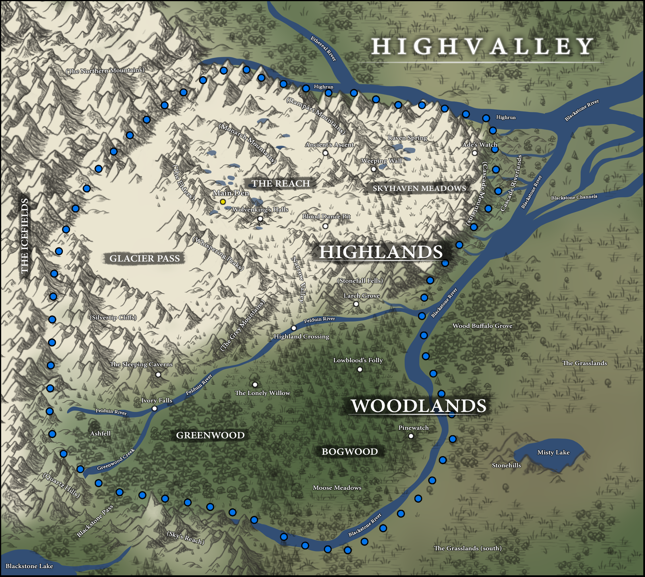
Highvalley Territory
M A I N D E N
Also known as the Valley of the Rocks; Highvalley’s main den is a sparsely-forested enclosed vale located within the The Reach that features a wild array of giant boulders—the remains of an ancient rockslide. The rockscape is dominated by a variety of mosses, lichens, flowers and shrubs. In the summer months, a small creek that runs through the rubble provides easy access to water for the pack. Underneath and in-between the giant boulders is where Highvalley wolves make their dens. They are small and scattered across the rockscape, generally fitting 1-3 wolves per den. Most are covered in a thick layers of moss, while others remain rugged and rocky. Caution should be used when scampering around the barren rocks, some of which teeter and clunk underpaw.
H I G H L A N D S
Average elevation = 2,500 meters (8,200 feet)
The Highlands encompass Highvalley’s mountainous territory which have been divided into three geographical sections: Skyhaven Meadows, The Reach, and Glacier pass. In the Highlands, the soaring peaks have been wedged together in areas known as the upper subalpine and alpine zones. Situated at an average elevation of 2,500 meters, this part of the realm is surrounded by sheer cliffs on every side; exceptions include a few small, accessible valleys to the south and the Icefields of the west. Conditions are unpredictable, as the weather can change in an instant. Due to high elevation, harsh winds, and a short growing season, the trees are thin, stunted, and sparse with some areas barren altogether. The Highlands are covered by snow from mid-October to mid-June and temperatures can drop below freezing in every season of the year.
:origin()/pre00/efd6/th/pre/f/2016/270/f/6/westernbiomes_by_naviira-daj2cmw.jpg)
 SKYHAVEN MEADOWS
Skyhaven Meadows, belonging to the eastern section of the Highlands, is a long stretch of rolling subalpine meadows and woods straddled in-between the Ramparts and Cascade Mountains. Abundant with wildlife and prey, it's gently rolling hills are some of the lushest in the Highlands: its forests are marked by alpine larches intertwined with alpine fir and Engelmann spruce, while heather and grouseberries form along the forest floor. Fragile wildflowers and lichens veil the land with color in mid-summer. In Autumn the scenery alters dramatically, with the larch trees turning yellow and red in the season's final burst of color.
- Ade's Watch
Since Highvalley's conception the pack has held a deep respect towards the Havirians for their ancient bloodline. As such, this wide subalpine plateau has been named in their honor; chosen for the expansive, eastward view it provides over the mountains beyond where Havir used to lie. If unsure of where to look, one only needs to look for the northern lights dancing vaguely above the far-off peaks. A short but steady climb uphill connects the plateau to the meadows below, making the landmark relatively easy to access. At its edge lies a several hundred food drop, so caution should always be taken on windy days.
- Raven Spring - Link |
The Raven Spring is a popular place to hang out, bond and play with other packmates on hot summer days due to the nearby shallow, spring-fed lakes. It's particularly a favorite among mothers with young pups. The gentle rolling meadows and sparse alpine forests here offer them plenty of vantage points to watch their young play and explore in a safe environment.
- Weeping Wall - Link | Link | Link
The Weeping Wall is an impressive 1000 foot high cliff. Throughout the spring and summer the cliff’s face is covered with tears of water pouring down from the top; it creates a veil of moisture and is fed by a spring originating higher on the mountain which never stops flowing. During winter the waterfalls freeze into towering pillars of ice.
THE REACH
South: At the center of the Highlands lies an alpine paradise worn smooth by glaciers, with larches manicured by wind and cold. Small, crystal blue alpine lakes can be found cradled in shallow basins, fed by glaciers scattered across the rugged landscape, strung together by a creek that tumbles and thunders between them. The land is dominated by smooth, white granite, with snow and ice culminating in the ridges and summits year-round. Gentle meadows of short grass and heather can be found sprinkled across the area. Mountain goats are common here.
North: As one ascends north of the Monarch Mountains, the lakes give way to a barren moonscape. Trees are rare, with the few that exist growing huddled together in what's known as scattered "islands"; they are small and stunted when compared to those found at lower elevations. This is the best place to hunt big horn sheep.
- Ancient's Ascent -
WIP
- Blood Dance Pit -
WIP
- Highland Crossing -
The Highland Crossing is a popular spot among the Highvallians to cross the normally turbulent Felduin river. This part of the river is shallow, allowing for a safe passage between the Woodlands and Highlands.
- Larch Grove -
The Larch Grove is a bluff on the southern end of the Stonefall Fells that is populated by a sparse larch forest. Look to the north and you get an impressive backdrop of sheer mountain cliffs of the Highlands. Look to the south and you get an expansive view of the Woodlands. It's often a place of quiet reflection.
- Narrow Valley -
Located at the southern end of The Reach, the Narrow Valley is the artery that connects the Highlands to the Woodlands. It's a steep climb, but it's the widest and safest way through the mountains, especially on warm winter days when the risk of avalanches is at its highest. While there are other secret, more remote ways through to the Highlands, this is the most accessible. Two members of the High Guard constantly keep watch at the top of the entrance by order of the High King.
- Wolvenking's Halls - Link
Also known as Tangle Falls, this delicate, multi-tiered cascade nestled in the centre of the Highlands serves as the High King's royal court. From the second tier, a rocky plateau protrudes from the middle of the spilling falls as a platform or "throne" for the monarch when holding an audience. The first tier of the falls spray 114 feet in as many as half a dozen intertwined braids off a broad, steep cliff, proving a very scenic and impressive backdrop for those in attendance.
GLACIER PASS
As you travel further west the terrain gives way to a massive, expansive pass, weaving alongside the Icefields to function as Highvalley's western border. Here, the terrain is tundra-like in appearance with rolling, talus fields almost completely devoid of trees. The pass itself is wide, having been carved through the land by ancient glaciers. In some areas, low, parallel ridges run the length of the pass revealing the direction in which the ice flowed. The vegetation consists of dwarf shrubs, sedges, grasses, mosses and lichens. A massive heard of caribou numbering in the thousands migrate through the pass every summer and winter.
- The Sleeping Caverns -
WIP
THE ICEFIELDS
Inspirations
Also known as the Frozen Waste, the Icefields is an extensive, mountainous area of ice and snow composed of interconnected valley glaciers flanking the outside of Highvalley's western border. With its severely frigid temperatures—in addition to other unseen dangers—travel upon this terrain is forbidden. While the plateau of the Icefield itself is relatively stable, it's the glacier "toes" that become a cause for concern: moving down from the Icefield at a rate of several centimeters per day, many hidden crevasses lurk just beneath the ice's surface. Should one survive the fall into a crevasse (which can be anywhere between 10-20m in depth) they would most certainly die from hypothermia.
Many travelers have perished attempting to traverse the Icefield, with only a couple of wolves in the Domain's history having survived the journey; according to legend, Highvalley's founding Alpha, Felduin, was one of them.
W O O D L A N D S
Average elevation = 1,200 meters (3,600 feet)
The Woodlands is a winter haven and the most heavily forested area in the territory with the greatest amount of biodiversity. From the complex wetlands of the Bogwood to the elaborate vegetation mosaics of the Greenwood, this part of the realm is used as the pack's main hunting grounds. Due to the lack of natural defense provided by mountainous terrain you'd find in the Highlands, the Woodland's borders are heavily patrolled. Because of the increased risk of stumbling upon intruders, the Alpha has made this area off-limits to both juveniles and pups, unless accompanied by an adult guardian. Owing to their proximity to the mountains, this part of the territory is known to produce frequent, booming thunderstorms in the summer months.
BOGWOOD
The Bogwood is a dark, heavily forested conifer forest, with several meadows and wetlands found throughout. Black spruce and tamarack dominate its damp and cold climate, making it a very popular area for moose and caribou.
- Highland Crossing -
The Highland Crossing is a popular spot among the Highvallians to cross the normally turbulent Felduin river. This part of the river is shallow, allowing for a safe passage between the Woodlands and Highlands.
- Lowblood's Folly -
WIP
- Moose Meadows - Link |
This small shrub meadow is a popular place to find Moose, hence its name. Occasionally this lowland is flooded, but the sedges and shrubs are well adapted to surviving waterlogged soil so they thrive where trees cannot
- Pinewatch -
WIP
GREENWOOD
The Greenwood is an ancient deciduous and conifer forest located to the west. Renowned for its mild weather, the landscape changes seasonally; the beauty of its wildflowers in the spring, deep green foliage in the summer, blazing colorful leaves of autumn, and a wondrous snowy wonderland in the winter are equally enjoyable. Highvalley wolves often utilize this area to hunt deer and elk.
- Ashfell -
WIP
- The Lonely Willow -
WIP
S U R R O U N D I N G L A N D M A R K S
- Blackstone Pass -
WIP'
- Cascade Riverlands -
WIP'
- The Grasslands -
WIP
- Stonehills -
WIP
- Wood Buffalo Grove -
WIP
M O U N T A I N R A N G E S
Cascade Mountains
As the easternmost mountain range of the Highlands, the Cascades are named after the countless, towering waterfalls found across their eastern faces. Its western slopes gently dip into the subalpine meadows and woods below, connecting smoothly to the alpine plateaus. However, the eastern slopes are extremely dangerous; from the sheer cliffs they fall several hundred feet to the ground, creating a natural border. These rocky heights act as a barricade, keeping both pack-wolves in and foreigners out, however there are a few pathways weaving in and out of these mountains that lead to special, secret places known to a few. The high winds and abrupt drops make travel through this range unadvisable; at the same time their protection is reliable, as they are nearly impossible to penetrate. Known for their pink-ish hue due to the amount of Gog Quartzite found in the rock, these mountains are considered some of the most beautiful in the region.
The Elders
Their rocky faces of these mountains help to shield the heart of The Reach from the terrible winds coming off of the Icefields. At its base lies the main den site. They are known as the "The Elders" because of their old, ruin-like appearance in comparison to the other great ranges in the territory. It is here at its base where the Main Den site is located.
The Grey Mountains
WIP
Monarch Mountains
The Monarch Mountains are a small mountain range "chain" of granite with seven distinct, sharp peaks. It acts as an important landmark that separates the northern and southern part of The Reach. The tallest peak of this range is named after the pack's founding Alpha: Felduin.
The Northern Mountains
This mountain range makes up Highvalley's north-western border. As a part of the icefields, travel through here is forbidden.
Quartz Hills
WIP
Rampart Mountains
Simply known as "The Ramparts," these mountains make Highvalley's northernmost border. Sitting at the highest elevation within the territory, their barren, grey cliffs are fraught with danger. Hanging glacier's sit high on the walls of what remains of the ancient glacier valley.
Silvertip Cliffs
WIP
Sky's Reach
WIP
Stonefall Fells
Lying east of the Narrow Valley, the Sundance range is dotted with steep canyons and small, lush valley channels. While it is possible to travel through this area, navigation is difficult.
Whispering Peaks
Along with "The Elders" the Whispering Peaks offer protection to the rest of Highlands from the cold, bitter winds that come off of the Icefields. The winds make soft whistling sounds as they swirl around these massive barriers for which the Whispering Peaks is named.
Ethereal River
WIP
Felduin River
WIP
Greenwood Creek
WIP
More landmarks will be added as they are discovered and explored, You are more than welcome to make suggestions for new landmarks!
Chandor Landmarks | Vale Landmarks | Aryn Landmarks | Fellfang Landmarks | Vektren Landmarks

Brush pack used:
Sketchy Cartography Brushes
R I V E R S & L A K E S
Blackstone Lake
WIP
Blackstone River
WIP
WIP
Blackstone River
WIP
Ethereal River
WIP
Felduin River
WIP
Greenwood Creek
WIP
More landmarks will be added as they are discovered and explored, You are more than welcome to make suggestions for new landmarks!
Chandor Landmarks | Vale Landmarks | Aryn Landmarks | Fellfang Landmarks | Vektren Landmarks
Brush pack used:
Sketchy Cartography Brushes
Image size
2246x2010px 17.83 MB
© 2016 - 2024 Naviira
Comments26
Join the community to add your comment. Already a deviant? Log In
wow im not even in dotw but this is amazing & well thoughtout and i love the pinterest inspiration images like woah